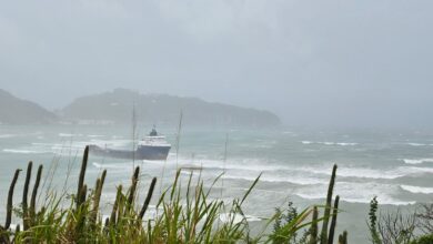
The tension on Sint Maarten/Saint Martin, as heard on Laser 101 FM, is palpable as Hurricane Maria begins to pass the island approximately 90 miles to the south. The coordinates of SXM are latitude 18.0708N and longitude 63.0501W. The storm is currently positioned at latitude 16.6N and longitude 63.6W, or slightly south.
The winds on the island are picking up but, at last report, the conditions have not reached tropical storm-force. The winds will likely last into the evening, with chances of them escalating throughout the day. Maximum sustained winds from Maria are currently at 160 mph (260 km/hr).
Here is a list of safety shelters in Sint Maarten where people can go to escape the storm.
Here is the complete latest update from the National Hurricane Center:
BULLETIN
Hurricane Maria Intermediate Advisory Number 14A
NWS National Hurricane Center Miami FL AL152017
200 PM AST Tue Sep 19 2017
…POTENTIALLY CATASTROPHIC HURRICANE MARIA MOVING ACROSS THE
NORTHEASTERN CARIBBEAN TOWARD THE VIRGIN ISLANDS AND PUERTO RICO…
…PREPARATIONS AGAINST LIFE-THREATENING STORM SURGE AND RAINFALL
FLOODING AND DESTRUCTIVE WINDS SHOULD BE RUSHED TO COMPLETION…
SUMMARY OF 200 PM AST…1800 UTC…INFORMATION
———————————————-
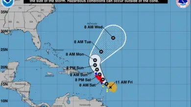
LOCATION…16.6N 63.6W
ABOUT 110 MI…175 KM SE OF ST. CROIX
ABOUT 140 MI…225 KM W OF GUADELOUPE
MAXIMUM SUSTAINED WINDS…160 MPH…260 KM/H
PRESENT MOVEMENT…WNW OR 300 DEGREES AT 10 MPH…17 KM/H
MINIMUM CENTRAL PRESSURE…927 MB…27.37 INCHES
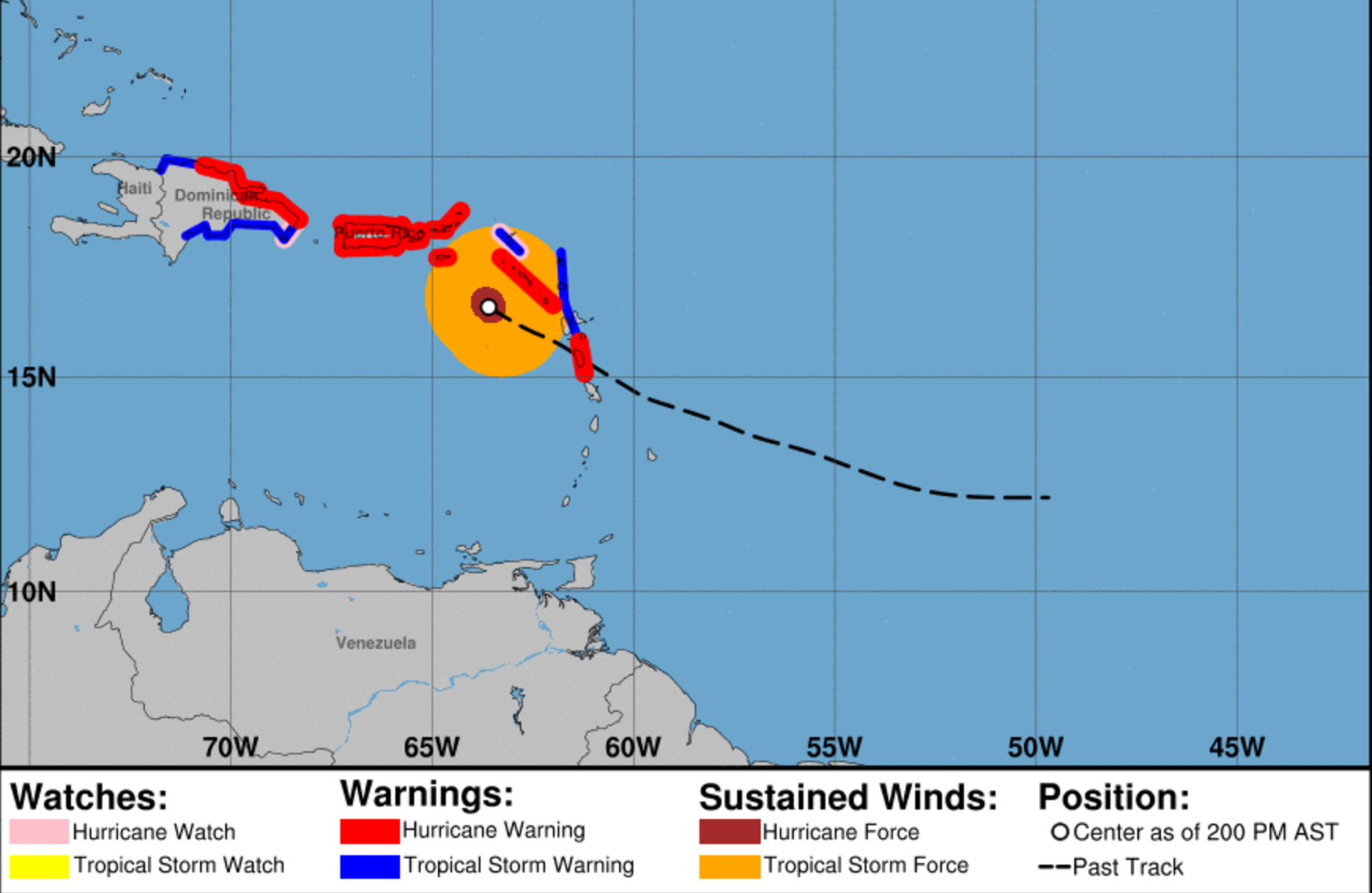
WATCHES AND WARNINGS
——————–
CHANGES WITH THIS ADVISORY:
The Meteorological Service of the Dominican Republic has issued a
Hurricane Warning from Cabo Engano to Puerto Plata, a Tropical
Storm Warning west of Puerto Plata to the northern border of the
Dominican Republic and Haiti, and a Tropical Storm Warning west of
Cabo Engano to Punta Palenque.
The Government of France has changed the Hurricane Warning for
Guadeloupe to a Tropical Storm Warning, and has discontinued the
Tropical Storm Warning for Martinique.
SUMMARY OF WATCHES AND WARNINGS IN EFFECT:
A Hurricane Warning is in effect for…
* Dominica
* St. Kitts, Nevis, and Montserrat
* U.S. Virgin Islands
* British Virgin Islands
* Puerto Rico, Culebra, and Vieques
* Cabo Engano to Puerto Plata
A Tropical Storm Warning is in effect for…
* Antigua and Barbuda
* Saba and St. Eustatius
* St. Maarten
* Anguilla
* Guadeloupe
* West of Puerto Plata to the northern border of the Dominican
Republic and Haiti
* West of Cabo Engano to Punta Palenque
A Hurricane Watch is in effect for…
* Saba and St. Eustatius
* St. Maarten
* St. Martin and St. Barthelemy
* Anguilla
* Isla Saona to Cabo Engano
A Hurricane Warning means that hurricane conditions are expected
somewhere within the warning area. Preparations to protect life and
property should be rushed to completion.
A Tropical Storm Warning means that tropical storm conditions are
expected somewhere within the warning area.
A Hurricane Watch means that hurricane conditions are possible
within the watch area. A watch is typically issued 48 hours before
the anticipated first occurrence of tropical-storm-force winds,
conditions that make outside preparations difficult or dangerous.
Interests elsewhere in Hispaniola, the southeastern Bahamas, and
the Turks and Caicos Islands should monitor the progress of Maria.
Additional watches and warnings may be required today.
For storm information specific to your area in the United States,
including possible inland watches and warnings, please monitor
products issued by your local National Weather Service forecast
office. For storm information specific to your area outside the
United States, please monitor products issued by your national
meteorological service.
DISCUSSION AND 48-HOUR OUTLOOK
——————————
At 200 PM AST (1800 UTC), the eye of Hurricane Maria was located
near latitude 16.6 North, longitude 63.6 West. Maria is moving
toward the west-northwest near 10 mph (17 km/h), and this general
motion is expected to continue through Wednesday night. On the
forecast track, the eye of Maria will move over the northeastern
Caribbean Sea today, and then pass near or over the Virgin Islands
overnight and Puerto Rico on Wednesday.
Maximum sustained winds are near 160 mph (260 km/h) with higher
gusts. Maria is a potentially catastrophic category 5 hurricane on
the Saffir-Simpson Hurricane Wind Scale. Some fluctuations in
intensity are likely during the next day or two, but Maria is
forecast to remain an extremely dangerous category 4 or 5 hurricane
until it moves near or over the Virgin Islands and Puerto Rico.
Hurricane-force winds extend outward up to 35 miles (55 km) from
the center and tropical-storm-force winds extend outward up to
140 miles (220 km). During the past few hours, the eye passed just
north of NOAA buoy 42060, which reported 1-min average winds of
85 mph (137 km/h) and a wind gust of 94 mph (151 km/h).
The estimated minimum central pressure is 927 mb (27.37 inches).
NOAA buoy 42060 reported a minimum pressure of 955.7 mb
(28.22 inches) as the eye passed.
HAZARDS AFFECTING LAND
———————-
WIND: Hurricane conditions will continue in portions of the
hurricane warning area in the Leeward Islands this afternoon,
and spread into the Virgin Islands and Puerto Rico tonight and
Wednesday. Tropical storm conditions are occuring over the
remainder of the Leeward Islands, and should spread into the Virgin
Islands and Puerto Rico starting in the next several hours.
Hurricane conditions are expected within the hurricane warning area
in the Dominican Republic late Wednesday, with tropical storm
conditions expected by early Wednesday. Tropical storm conditions
are expected in the tropical storm warning areas in the Dominican
Republic on Wednesday.
Wind speeds atop and on the windward sides of hills and mountains
and on high-rise buildings could be much stronger than the near-
surface winds indicated in this advisory.
STORM SURGE: A dangerous storm surge accompanied by large and
destructive waves will raise water levels by as much as 7 to 11
feet above normal tide levels in the hurricane warning area near
where the center of Maria moves across the Leeward Islands and the
British Virgin Islands.
The combination of a dangerous storm surge and the tide will cause
normally dry areas near the coast to be flooded by rising waters
moving inland from the shoreline. The water is expected to reach
the following heights above ground if the peak surge occurs at the
time of high tide…
Puerto Rico and the U.S. Virgin Islands…6 to 9 ft
The deepest water will occur along the immediate coast near and to
the north and east of the landfall location, where the surge will be
accompanied by large and destructive waves. Surge-related
flooding depends on the relative timing of the surge and the tidal
cycle, and can vary greatly over short distances. For information
specific to your area, please see products issued by your local
National Weather Service forecast office.
RAINFALL: Maria is expected to produce the following rain
accumulations through Thursday:
Central and southern Leeward Islands…10 to 15 inches, isolated 20
inches.
U.S. and British Virgin Islands…10 to 15 inches, isolated 20
inches.
Puerto Rico…12 to 18 inches, isolated 25 inches.
Northern Leeward Islands from Barbuda to Anguilla…4 to 8 inches,
isolated 10 inches.
Windward Islands and Barbados…2 to 4 inches, isolated 6 inches.
Eastern Dominican Republic…4 to 8 inches, isolated 12 inches.
Rainfall on all of these islands will cause life-threatening flash
floods and mudslides.
SURF: Swells generated by Maria are affecting the Lesser Antilles.
These swells are likely to cause life-threatening surf and rip
current conditions. Please consult products from your local
weather office.
NEXT ADVISORY
————-
Next complete advisory at 500 PM AST. Hourly Tropical Cyclone
Updates will commence at 300 PM AST as the eye is now well-defined
in data from the San Juan Doppler radar.